News
Update Available for Android Mobile App
An update of the CBIBS mobile app for Android is now available. Users who update to the new version will be able to monitor new CBIBS parameters that were activated earlier this summer—heat index and sea nettle probability.
CBIBS Buoys Track Derecho Data
Late on Friday, June 29, a straight-line windstorm known as a “derecho” and associated severe thunderstorms hit the Chesapeake Bay watershed.
Susquehanna Buoy Redeployed
 The Susquehanna CBIBS buoy, located at the mouth of the Susquehanna River near Havre de Gr
CBIBS Science Users' Forum Recap
On February 28, the NOAA Chesapeake Bay Office, which manages the Chesapeake Bay Interpretive Buoy System (CBIBS), welcomed regional scientists and observation network experts to talk about how they currently use data from CBIBS—and how they might in the future.
CBIBS Tracks Warm Waters, in Contrast to Last Winter
Early last year (January 2011), roughly 2 million dead fish—primarily young spot—washed ashore in the mid Chesapeake Bay.
Some Sensors Down on First Landing Buoy
Soon after the CBIBS field team got the First Landing buoy back up and running from repairs to damage from Hurricane Irene, the buoy sustained additional damage to its top structure, including the anemometer and temperature/humidity sensor.
Susquehanna Buoy Out of Water for Winter
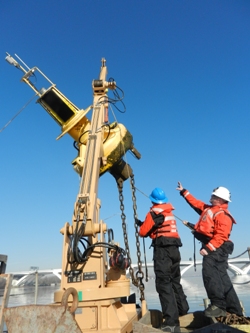
Thanks to U.S. Coast Guard Baltimore, the Susquehanna CBIBS buoy was pulled from the water today for over the winter. The buoy's location as the northernmost CBIBS buoy and at the mouth of the Susquehanna River means it is in relatively fresh water that is quite susceptible to freezing.
First Landing Buoy Back On Line
 The First Landing buoy—the tenth buoy in the Chesapeake Bay Interpretive Bu
CBIBS Buoy Data Helps Scientists Research Irene, Lee Effects
NOAA Chesapeake Bay Office scientists have been busy in the wake of Hurricane Irene (August 27-28) and the flooding rainfall associated with the remnants of Tropical Storm Lee (week of September 5).


