
Each spring, the CBIBS team looks forward to redeploying buoys that were pulled late the previous year to avoid potential damage to them by ice over the winter. In 2019, the redeployments are a bit more complex as CBIBS is transitioning to using a new kind of buoy.
First deployed as far back as 2007, the “old” buoys are showing significant signs of age, and their size has posed challenges to the CBIBS team. Knowing the buoys would need to be replaced, the team selected a “new” buoy that can hold all the same sensors as the old buoys, but on a smaller hull. That will make operations and maintenance of the buoys easier for the CBIBS team.
The new buoys also update meteorological conditions every six minutes—more frequently than the old buoys, which updated every ten minutes. Other NOAA coastal and estuarine systems follow this protocol as well.
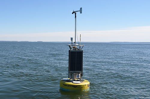
The new buoys are smaller but just as capable as the old buoys. And, they’re still yellow!
Purchasing the hulls and all other needed parts is a long process—and one that is still evolving. It is likely that due to delays in acquiring hulls and needed parts, we will be unable to deploy buoys at all ten locations in 2019. In addition, the team is carefully testing the new buoys as they are deployed to ensure all components behave well when they are on the water. The goal is to build the system out in a measured way to ensure reliability.
While plans may change, the CBIBS team wants constituents to know what the status and plans for each buoy looks like (updates will be provided here as the year progresses):
- Stingray Point and Gooses Reef locations are operational with new buoys. Plans are in the works to add the bottom lander, tracking conditions 40 feet below the main buoy, to the Gooses Reef location in the near future.
- A new buoy will be deployed at the Jamestown location later in March. There is currently no buoy at this location, which provides needed data to the National Weather Service and supports operations of a ferry. Data from this buoy, which sees the largest range of salinity of all the buoy locations, also supports NOAA computer models that forecast levels of the bacteria Vibrio. Vibrio can affect species like oysters, posing health risks for humans.
- The Annapolis location provides data used to help make a large recreational boating community make decisions that support a safe day on the water. We are awaiting parts to enable deploying a buoy here—this is planned for April.
- York Spit and First Landing currently are operational with old buoys. Once the hulls and parts for these buoys are assembled, the team will swap old for new buoys at these locations, likely in May. Point Lookout is also currently operational as an old buoy.
- Patapsco currently has no buoy; it is under construction, and the anticipated launch date is still to be determined. This buoy supports commercial shipping as ships transit into Baltimore.
- At the moment, it does not appear we will deploy buoys at the Upper Potomac or Susquehanna locations in 2019. We know there are recreational fishermen who use data from these locations, and strive to restore data. While the Susquehanna buoy is not on station, the “CB1.1 Susquehanna River” data from Maryland Department of Natural Resources’ Eyes on the Bay provides data that can be helpful for anglers, including water temperature and salinity. For Upper Potomac, the “TF2.1 Off Piscataway” Eyes on the Bay location is a few miles downstream of the Upper Potomac buoy location, and another NOAA station that includes water and meteorological information is upstream a few miles at Washington, D.C.